

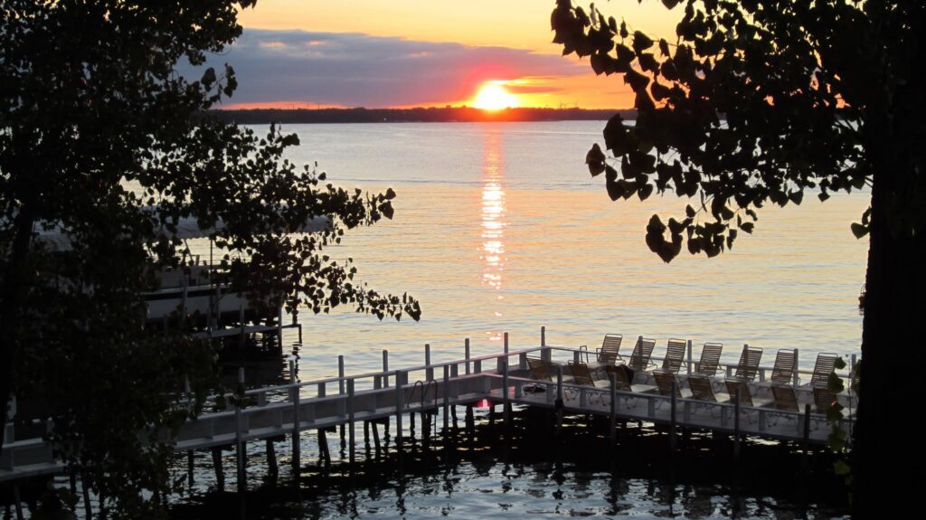
West Lake Okoboji is the deepest natural lake in Iowa. The Iowa DNR puts it at 138.9 feet at the deepest point, across 3,847 surface acres, which is more than six times the maximum depth of East Okoboji two miles to the east. A glacier cut it, and in July 2026 a groundwater study finally explained how: a buried block of ice and one violent flood carved a deep tunnel valley that later filled with water. Two things you have probably read about this lake are not true. It is not one of only three blue water lakes in the world, and it is not fed by some great underground spring.
Key Takeaways
- The Iowa DNR lists West Lake Okoboji at 138.9 feet maximum depth and 3,847 surface acres, from a 2014 survey.
- The “one of only three blue water lakes in the world” line is a century-old myth, and the DNR has said as much.
- In July 2026 the Iowa Geological Survey gave the depth a cause: buried glacial ice and a single catastrophic flood cut a tunnel valley.
- “Spring-fed” is a stretch. In a normal year most of the water arriving is surface runoff from small tributaries, not groundwater.
- Five connected lakes share one water level, set by a single dam at the south end of Lower Gar.
Most people arrive in Arnolds Park knowing two things about this lake: it is blue, and it is deep. Both are roughly true. Nearly everything attached to those two facts on signs and in brochures got garbled somewhere along the way, and one claim has been wrong for about a hundred years. Guests ask us about it every June, so here is the version that holds up.
How deep is West Lake Okoboji?
138.9 feet at the deepest point. That figure comes from the Iowa DNR’s lake record for West Okoboji and reflects a 2014 survey. Mean depth sits around 39 feet, the surface covers 3,847 acres, and the watershed draining into the lake runs roughly 125 square miles.
You will see other numbers, and you should not be surprised. 136 is the most common of them, and it is simply the older figure, still in wide circulation and still sitting in our own archive. 134 turns up too, and one regional account notes historical measurements as high as 160 feet. That last number says more about a century of changing survey methods than about the lake. If you want one figure to use, use the DNR’s.
The comparison that means something is the one next door. The DNR lists East Okoboji at 21 feet at its deepest. Same glacier, same county, two miles apart, and one lake is more than six times deeper than the other. That gap is the whole story of this lake. For a long time nobody could explain it.
Is it one of only three blue water lakes in the world?
No. The other two are usually given as Lake Geneva and Lake Louise, and the claim has run in tour guides, newspapers and real estate listings since the early twentieth century. It has appeared on this website too.
The Iowa DNR took it on directly in an article on the blue water claim, first published in Iowa Outdoors magazine. The short version: “blue water lake” is not a scientific term and carries no real definition. Legend holds that National Geographic gave the lake the title, but no such article has ever been found. The likelier origin is an early twentieth century study comparing West Okoboji to Lake Geneva, and local boosters who ran with it. An Iowa State professor said much the same in a newspaper column in 1985, so this is not a new correction. It is one nobody wanted, and it sold a great deal of postcard stock.
Clear water looks blue because sunlight entering it loses the other wavelengths first, and most lakes carry enough dissolved organic matter to absorb the blue along with everything else. This one does not carry much of it. The DNR includes West Lake Okoboji on its Outstanding Iowa Waters list, a short roster of waters held above the state minimum, which means the lake is not permitted to degrade to merely acceptable. That designation has teeth. The slogan does not.
How did it get so much deeper than the other lakes?
That was an open question until two months ago.
The Wisconsin glacier pushed into this corner of Iowa roughly 17,000 years ago. When it pulled back it left the landscape you drive through now: low rounded knolls, marshy hollows, a scatter of shallow kettle lakes. East Okoboji, Big Spirit and Center Lake all fit that pattern. West Okoboji does not, and that was the problem.
In July 2026 the Iowa Geological Survey published its answer, out of a groundwater study funded through the DNR’s Lake Restoration Plan. Mapping the lakebed and the sediments under it, geologists Phil Kerr and Thomas Doyle identified a previously unknown tongue of ice, which they named the Okoboji Sublobe, that moved south alongside the main Des Moines Lobe and then over the top of it as the larger glacier collapsed. Where the two collided they buried enormous chunks of ice. When the glacier finally retreated, one of those buried blocks and a single catastrophic flood of meltwater cut a deep tunnel river valley. That valley is the lake.
The detail that gave it away is one any swimmer here has felt without knowing what it was. Doyle noticed a shelf jutting from both sides of the very steep lakebed about 60 feet down, before the bottom drops away again. The shelf sits at the same elevation as buried sand and gravel north of the lake, which made it the shoulder of an old river valley the glacier had covered over. Push off from a dock here and the bottom does not slope politely away from you the way it does on East Okoboji. It falls. Now there is a reason for that.
Is West Lake Okoboji spring-fed?
Not in the way the phrase suggests, and it is the same study that settles it.
Alongside the geology, the Iowa Geological Survey team drilled thirty groundwater monitoring wells around the lake and installed stream gauges to trace where the water actually comes from. Groundwater here turns out to be local, and to stay local. Most of what moves through the glacial till discharges into the nearest wetland and leaves through evaporation and plant uptake, never reaching the lake at all. In a normal water year the large majority of inflow is surface runoff arriving through small tributaries. In a dry year, groundwater’s share climbs. The researchers call the system seasonal and flashy, which means the balance shifts a good deal with how much rain a year brings.
So there is no vast spring under the lake feeding it from below. The water is clear because of the shape of the basin, not because of a hidden source. It is the less dramatic answer, and it is the right one.
Why is the water clear, and cold down deep?
Because a deep lake sorts itself into layers and mostly leaves them alone. Through the summer a warm surface layer sits on much colder water and the two do not mix. University of Iowa hydroscience researchers have put the effect plainly: the lake’s depth holds incoming nutrients down below the surface layer, so the top of the lake stays relatively unaffected by what washes in. In autumn the surface cools, grows heavier than what is beneath it, sinks, and the whole column turns over. That is the annual reset.
The practical version, if you are swimming or skiing: the surface can sit in the mid-seventies in July while the water 40 feet down is still in the forties. That same depth is why this lake warms late in spring and holds its heat into September, which we break down in our month-by-month guide to West Lake Okoboji water temperature.
Clear does not mean pristine, and you should hear that from us rather than from a review. The DNR logged a slight algae bloom in August 2026, with clarity still holding. Zebra mussels were confirmed here in 2013, and their shells are why water shoes are a good idea on any rocky stretch, our own North Beach shoreline included. Eurasian watermilfoil has needed treatment in the canals and bays, most recently in 2023. The DNR monitors public beaches for bacteria through the season and posts advisories when readings warrant, so it is worth checking the DNR’s aquatic invasive species guidance and the current beach postings before a trip. The lake is in good shape, and it is not in perfect shape, and the difference is worth knowing about before you put a kid in it.
Which lakes connect to West Lake Okoboji?
Five, and the DNR is specific about which. West Okoboji, East Okoboji, Upper Gar, Minnewashta and Lower Gar are the five connected lakes of the Iowa Great Lakes chain. Big Spirit is the largest natural lake in the state and sits in the same region, but it is not part of that connected run, and it is worth not confusing the two.
Because they are joined, all five sit at one level, and that level is set at a single point: the dam at the south end of Lower Gar. When the lake is low, it is low everywhere in the chain at once. If you bring your own boat, you can run from our dock down through the Gars without ever touching a trailer. If you do not, it at least explains why the shoreline sits where it does some summers and not others. It is one water level, not five.
Where the lake’s numbers come from
There are two sources worth bookmarking before you drive up, and both are free.
The USGS has operated gauge 06604200, West Okoboji Lake at Lakeside Lab, since May 1933, with daily water temperature records going back to October 2011. Ninety-odd years of lake level on one lake is not common, and it is why any claim that this water ran higher or lower in a given decade can actually be checked instead of argued about.
The second is a research buoy run by Iowa Lakeside Laboratory, reporting surface temperature, dissolved oxygen, pH and weather every ten minutes into a global network of monitored lakes. Lakeside Lab has been studying this water since 1909, and the buoy is anchored in deep water off Sunset Beach, the stretch of shoreline we sit on. When somebody tells you the lake is 71 degrees today, that buoy is usually where the number came from. If you would rather not hunt for the figures yourself, the Iowa Great Lakes Water Safety Council keeps the level and temperature links in one place.
Where Fillenwarth Beach sits on the lake
Fillenwarth Beach runs about half a mile of Sunset Beach shoreline on the east shore, in four sections: Main Beach with the largest dock on the lake, North Beach with its rockier glacial shoreline, South Beach alongside one of the better natural sand beaches in the area, and Cottage Colony across the road. The shoreline faces west, which is why the evening light here is what it is.
Why the lake matters to a week with us and not to a drive-by is that our activities happen on it and are included rather than rented. 45-minute afternoon cruises on the two 49-foot Sun Runners. Water skiing with instruction on tournament boats. Sailboat rides on the 28-foot scow. Canoes, rowboats and paddle boats sitting self-serve on the dock, with the paddles in the rack and life jackets in the bin. Boats and sailing are weather permitting, and on a lake this deep and this cold that is not a formality.
FAQ
How deep is West Lake Okoboji?
138.9 feet at the deepest point, from the Iowa DNR’s 2014 survey, with a mean depth of about 39 feet. That makes it the deepest natural lake in Iowa by a wide margin. The 136-foot figure you will see on a lot of sites is an older number still being repeated, and it is not wrong so much as out of date.
Is West Lake Okoboji one of only three blue water lakes in the world?
No. The Iowa DNR has stated that “blue water lake” is not a scientific term and carries no real definition, and no source has ever been found for the three-lakes claim. The lake does have genuinely exceptional water quality, and the DNR includes it on its Outstanding Iowa Waters list.
Is the lake spring-fed?
Not in any meaningful way. A 2026 Iowa Geological Survey study found that local groundwater mostly discharges into nearby wetlands and never reaches the lake, and that in a typical year most inflow is surface runoff from small tributaries. Groundwater’s share rises in dry years. The phrase has been doing the lake a disservice for a long time.
Can you boat from West Lake Okoboji to the other lakes?
Yes. West Okoboji, East Okoboji, Upper Gar, Minnewashta and Lower Gar are connected, so you can run the chain without trailering. All five share one water level, controlled by the dam at the south end of Lower Gar.
Is the water cold?
The surface warms into the seventies by midsummer, but because the lake is so deep it warms later in spring and cools later in fall than the shallower lakes nearby, and the water well below the surface stays cold all season long. Our water temperature guide breaks it down month by month.
If you would rather see this lake from the middle of it than from the shore, we have been putting families on the water here since 1918 and the boats come with the stay. There is no online booking. Call (712) 332-5646 or use the reservations form, and someone who knows all 38 unit types will pick up. We do not accept credit or debit cards, so it is worth asking about payment when you call.